
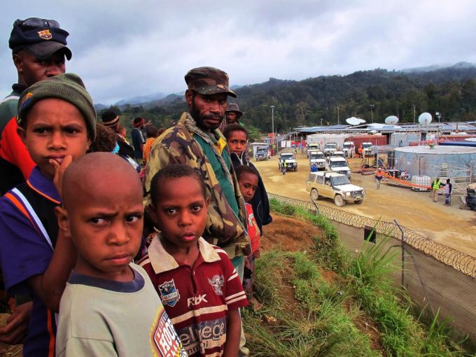
The Papua New Guinea Liquefied Natural Gas (PNG LNG) project commenced exporting gas to China, Korea and Japan in May 2014. Under agreements reached in 2009, landowners of eight petroleum licence areas, eight pipeline licence areas and a liquefaction plant site near Port Moresby were to receive royalties. By February 2019, payments had been made to people in only the last of these areas. The identification of landowners has been a major difficulty, and assigning responsibility for completing the task has been a matter of debate.
At the close of 2018, social mapping and landowner identification studies carried out by consultants to petroleum companies, clan-vetting exercises carried out by officers of the Department of Petroleum and Energy, and alternative dispute resolution processes implemented by the judiciary had failed to solve the problem. By this time too, agreements for two other LNG projects (in Western Province and Gulf Province) were under discussion. In January 2019, Petroleum Minister Fabian Pok told parliament that the government would not repeat the mistakes of the first LNG project. He wanted the companies to be responsible for identifying landowners in the new LNG project areas and he wanted this done before those projects moved to production. On January 23rd, referring to the Gulf Province LNG project, Prime Minister Peter O’Neill said that the government “had tasked the developer to do the landowner identification process” and Minister Pok reported that Total – the developer – had agreed to do this.
The small print is not yet to hand so we cannot be sure just what the government has requested or what Total has agreed to do. Here, however, we argue that ceding responsibility for landowner identification to the petroleum companies is a seriously bad idea – bad for the companies, the government and for the people of Papua New Guinea.
Under the Oil & Gas Act 1998, final determination of landowner beneficiaries for a petroleum licence area is to be made by the responsible minister and gazetted as a Ministerial Determination. Recent determinations provide a record of landowner beneficiary identification for specified licence areas or pipeline segments. Those determinations name clans (variously ‘major clans’, ‘stock clans’, ‘beneficiary clans’) but do not name individuals within those clans. With reference to differential benefit-sharing arrangements they may subdivide clans as ‘highly impacted’, ‘least impacted’ and ‘invited’.
The diagram below shows some categories of landowner beneficiaries appearing in recent determinations and in clan-vetting exercises that precede and feed into those determinations. On the diagram, the boundaries of the lands of clans A to G are shown relative to a Petroleum Development Licence (PDL) area. Clans A, B and C are classed as landowner beneficiaries on the basis of long-term residence and use. Clans D and E are ‘invitees’ initially recognised as landowner beneficiaries on the basis of boundary-sharing with A, B or C with the possibility that they are subsequently granted equivalence with those clans. Clan F is classed as a landowner beneficiary on the basis of asserted ancestral connection and an ideology of rights to land being held in perpetuity. Clan G is an ‘invitee’ recognised as a landowner beneficiary on the basis of assistance rendered to A, B and C. H is a private citizen, or group, that holds registered title to a portion of the PDL area and, on this basis, under the Act is a landowner beneficiary.

The concept of ‘landowner’ is being used here in a broad and fluid sense. It is not used in agreement with any likely academic definition, with any detectable legal rigour or in conformity with a pan-PNG ideology of tenure because, of course, there is no pan-PNG ideology of tenure. The Oil & Gas Act requires that a company applying for a PDL must submit a “full-scale social mapping study and landowner identification study of customary land owners” of that licence area. Under the Act, customary landowners are persons whose relationship with the land has to do with “rights of proprietary or possessory kind”. Not all clans identified as landowner beneficiaries in Ministerial Determinations satisfy this definition. And the status of others, both the included and the excluded, as members of this category will be always amenable to contention. Several possibilities are implied in the diagram.
For example, a judgement that clan C was ‘more impacted’ than A or B because all land attributed to C is within the PDL area while portions of land attributed to A and B lie outside that area, could be challenged by the latter clans on the basis of area or numbers of people affected. Similarly, members of A, B or C could well have different opinions regarding acceptance of D or E as ‘invitees’ and their possible upgrading to the status of landowner is even more problematic in being politically, rather than empirically, motivated. Inclusion of F as landowner will be dependent on assessing the validity of accounts of ancestral connections from claimants who may well have competing agendas. Finally, inclusion of G could elicit claims from other clans that assert that they too provided assistance to A, B and C. Resolving problems of these kinds cannot be achieved by an anthropological study of ‘in situ’ land ownership. These sorts of problems are ultimately resolved only by facilitated negotiation with those charged with identifying landowners, or by litigation.
No petroleum company can produce a list of clans that will conform to, or satisfy, the sorts of decisions that currently inform Ministerial Determinations. They did not do so in the past and they cannot do so in the future. If companies now assume responsibility for producing a definitive list of landowner beneficiaries, there will no longer be any ambiguity about who to blame or who to take to court when the list is considered defective. The fault will be theirs. On these counts, the desire to shift responsibility – or at least the perception of responsibility – to the petroleum companies might, in the short term, prove beneficial to the government in domains of financial management and public relations.
There is, however, another reason why responsibility for identifying landowners should remain with the government. Only Papua New Guineans – the PNG government, courts, and the landowners themselves – can determine who owns the land in Papua New Guinea. This responsibility should not be ceded to outsiders. It should not be ceded to American, Australian, Chinese or French companies. Papua New Guinea is not their country. They are guests. Only Papua New Guineans can determine what is right for Papua New Guinea. The petroleum companies should recognise and acknowledge this and step back from this area of decision-making. The government should also recognise and acknowledge this and step forward to ensure that the rights of all Papua New Guinean woman and men are guaranteed by Papua New Guineans.


We can all appreciate criticisms when they are presented with detail and substantiated counter-facts. Vailala would have us believe the SMLIs for PNG LNG and P’nyang “drifted into absurdities”. There were in total 7 researchers across these projects all with PhDs, 10+ years researching/teaching in Universities, multiple international publications and with either longstanding fieldwork in the cultures they reported on, in cultures exhibiting regional patters and/or peer reviewed by others who had previously worked in the area. I am assuming Vailala would at the very least agree these people are preferable to a Toyota mechanic for the purposes of conducting work on project area landowners? I could write a book on the complexities of SMLI in a development cauldron, the way landowners strategise and play with social structural principles in these situations. More constructively, however, the point I would prefer here to make is (a) the decisions a Minister makes about ‘beneficiaries’ is not and does not have to be solely reliant on the SMLI – other matters and submissions may come into play; (b) the weak link in the process is that there is no compulsion on the Government to liaise with the SMLI authors to seek clarification and interpretation when forming views on beneficiaries. In other words, if the SMLI was ‘workshopped’ between the parties in the endeavour of identifying beneficiaries, better value would emerge from the considerable resources es spent producing the SMLIs. Lastly, it would be more helpful if Vailala would, for example, provide just 1 example from the 500+ identifications made in the project SMLIs where they “got it wrong” or “drifted into absurdity”!
We can hold on to our Customary Land Titles and ILG Certificates but we will only be compensated for it while the Law of our land (PNG) doesn’t recognize us with our Titles and Certificates.
There is No Law that recognizes Landowners to buy shares in the projects we claim to be ours on our Traditional Customary Land.
This is a sad fact.
All our Resources belong to the State as the Mama Land Laws favor the State and the Developers.
Drastic changes to our Mama Laws need to be amended for the Landowners to buy shares in our Resource Projects so as to benefit as much as we can.
Colonial Laws on Mining and Petroleum that we adopted through Independence are long OVERDUE.
i maua akia just want to say on behalf of my land toru Koai koai that i have a social mapping for my land of Papua LNG
Is the Social Mapping & Landowners Identification or SMLI Report for PRL 15 Papua LNG being completed and handed over to the PNG Government through Department of Petroleum/Energy to resume ‘Clan Vetting’ process of identifying missed out ‘Clans’ as beneficiaries of the Project?
Ankave tribe are still struggling to get their ILG.
Ankave Tribe
We will not entertain any investors into our Land with out our consultation Kariava oil and gas.
We don’t to do the same mistake again. We learnt that the world have just turn away from us Ankave tribe.
Papua New Guinea government also robbed us our rights to access to Puplic service.
There should no be no Play games.
Ankave tribes struggled from 2015 to 2022 to get Land Resister the Land get ILG.
The PNG LNG Gas Agreement dated 22 May 2008 ( https://www.banktrack.org/download/png_lng_gas_agreement/080522_pnglngagreementexecutionversion.pdf) describes in Exhibit J the ‘Protocols for Social Mapping and Landowner Identification Studies’.
Under the heading of ‘social organisation’ consultants are expected to ‘provide a description of clan structure, migration history, provenance and present organisation of people … principles of group formation (kinship and descent), leadership, identity and genealogies …’
Under the heading of ‘Mapping Results/Findings’ consultants are required ‘To provide a preliminary distribution map showing the relative positions of major groupings such as clans in the area – a ‘group to ground’ grid with an understanding of applicable land tenure principles and concepts.’
The SMLIS reporting requirements described in Exhibit J closely mirror the pre-independence colonial administration reporting practice.
Conspicuous by their absence from the Exhibit J reporting requirements are any references to PNG legislation relevant to the determination of customary landownership. The Ministerial informational requirements imposed by the Oil and Gas Act are also not mentioned.
Given the limited (and backwards looking) vision imposed on the consultants by Exhibit J it is understandable that they were not able to contribute in any meaningful way to a Ministerial Determination of inter-group landowner benefit sharing arrangements.
The SMLIS consultants and their reports have no legislated for processual standing in an OGA sanctioned benefit sharing agreement.
I think that Anura Widana’s post summarises the process of landowner identification in admirably simple and straightforward terms. I agree with Anura that identifying landowners is a joint responsibility shared by developer and GoPNG. The developer’s interest in landowner identification includes the need to engage with local companies, facilitate employment of local labour, and the OGA requirement for the developer to pay landowners compensation for entry to land, disturbances to land and occupation of land.
In regard to your concerns about the Papua LNG Project the Chairman of Total was today reported as saying ‘[t]he Papua LNG Project is completing all environmental and social studies including the important SMLI (Social Mapping and Landowner Identification) studies. The SMLI process and methodology has been enhanced, and with the Department of Petroleum’s guidance and counsel, ensures that a strong report will be submitted for the vetting.’ https://www.thenational.com.pg/construction-of-papua-lng-to-start-in-2021/
The National also reported PM O’Neill’s views- ‘On landowner identification in Gulf, O’Neill said he understood that most of them had been issued with identification cards “so that they are fully identified as genuine landowners”. “We certainly do not want to repeat the mistakes of the past where even today our minister is trying to determine the real landowners in Hela and Southern Highlands.” https://www.thenational.com.pg/gas-deal-is-on/
Vailala
Kariava has total of 8 oil wells and 10 gas reserves. It should be owned by Ankave tribe the people occupying the valleys between Vailala river and the Ivory river. Current ILG is upper Vailala mountain resources. It is not beneficial to the Ankave. Need new ILG.
From Peter D. Dwyer and Monica Minnegal
Vailala. Once again, your emphasis is with the abstractions of the law while ours is with what people are actually doing on the ground. Now, however, you imply that you have access to special knowledge regarding the intentions of Total, Oil Search and ExxonMobil and the possibility that GoPNG will activate a draft regulation that has been languishing for fifteen years. If you want a response to your comment then you must either reference that knowledge so that we can access it and judge for ourselves or you must identify yourself so that we may assess your credentials. If you do not do at least one of these things then you are not engaging in open debate.
From Peter D. Dwyer and Monica Minnegal
Thanks Trevor. Like Anura, you note that ‘the government does not have the capacity to perform [landowner identification] in a meaningful or timely manner’. At this juncture we do not want to abandon all hope in the PNG government. We do not want any international company to emerge as the de facto state. We are not asserting that senior politicians and bureaucrats fail with respect to competence. Some reports imply that they manage personal finances with great competence. We are asserting failures with respect to responsibility.
From Peter D. Dwyer and Monica Minnegal
Thanks to Anura Widana for his comment on our article.
Part of the reason that Anura’s view differs from ours concerns the title. The title we submitted was ‘Landowner identification in PNG: whose responsibility?’ In the editing process ‘Whose responsibility?’ transmogrified into ‘a job for Government’, and a subtlety we intended was lost. We wrote that ‘Only Papua New Guineans – the PNG government, courts, and the landowners themselves – can determine who owns the land in Papua New Guinea’ and, reflecting upon some recent statements by government ministers, we stated that ‘this responsibility should not be ceded to outsiders’. We did not, and would not, argue that developers should not contribute financially or practically to getting the job done.
Anura asks ‘how does the government alone identify land owners when the impact zone is known only to the developer?’ With petroleum projects the impact zone is, in fact, determined by government. It is the land enclosed by the graticular blocks that are included within a state-awarded petroleum licence area and it the land enclosed by a buffer zone of fixed dimensions associated with any state-awarded pipeline right-of-way or other infrastructure essential to the project. Thus, in the PNG LNG project it is the government that establishes the impact area. Where, as often happens, beneficiary landowners are identified from outside this area the fault (if fault it is) is more often that of state agencies than it is that of the developer. If, in line with Anura’s question, there are other types of projects where the developer, but not the government, knows the impact zone then surely this points to incompetence on the part of those state agencies that authorized the project.
Anura comments as well that the government ‘has capacity issues’ and ‘does not have incentives to start and work through the process’ so that ‘land owner identification becomes excessively delayed’ with deleterious effects ‘on the development work itself’. On these counts, it seems, he is arguing that government should not be ‘left with the responsibility to identify land owners’. The implication is that in Papua New Guinea, developers should assume the responsibilities of the state because the state is not up to the task. That is potentially dangerous, posing risks for the long term future of PNG. We think the capability exists and that it is time it was implemented by Papua New Guineans for Papua New Guineans.
The Papua LNG gas agreement is scheduled to be finalised in early April and an agreement between the state and the P’nyang joint venture may be finalized soon after. There have been many promises from senior Papua New Guinea politicians and bureaucrats that, this time, they would get it right. That will be possible only if they assume, and act on, their responsibilities.
I basically agree with Peter and Monica regarding the responsibility for landowner identification being the responsibility of the Government. However, the government does not have the capacity to perform this activity in a meaningful or timely manner.
While the initial SMLI is performed by the Developer, the Government is required by teh Gas Act to perform its verification of the data submitted by the Developer before Ministerial Determination. However, the government must perform their verification activity in a thorough and vigilant manner even if they require logistic support from the Developer
Anura is so correct. There are many examples of perpetual grief for landowners across PNG where SMLI has not been thorough and complete. Think of Bougainville Copper, Ramu Nickel and more recently the Hides region in relation to PNG LNG.
Government is so poorly resourced it is unable to perform such detailed activities on the ground in remote area. The Developers simply have little choice but to lead the government otherwise face an even more painful and costly project implementation due to disenfranchised landowners and other opportunist.
Having worked in 15 road construction, 1 major port construction, 30 bridge construction and 3 power generation/electricity distribution projects in PNG, my view on the subject is different from authors of this blogpost. My team has been responsible for the relocation and impacts management of over 3,000 households resulting from above projects over 10 years.
The primary question is how does the government alone identify land owners when the impact zone is known only to the developer? Similarly, the nature of impacts are also known to the developer and not the government. The analysis of nature of impacts is important to identify mitigation measures to reduce if not unable to avoid.
Our experience provides adequate evidence that land owner identification is the joint responsibility of the developer and the government (includes land owner entity). The best approach is to form a team comprising of representatives of land owner tribes/groups, other community members, district land officials and the social/land acquisition specialist of the developer, headed by the latter. This approach has worked satisfactorily over several years across different types of projects. Our recommendations for the team include:
– work from the ground level
-inform all land owners about the process by conducting meetings, discussions
-identify all impacted land parcel by team’s physical inspection
-noting down details including tribal contacts
-full documentation of process as well as the outcome
-transparency of information
We have found that government does has capacity issues and does not have incentives to start and work through the process. Decisions are delayed and land owner identification becomes excessively delayed that has a significant impact on the development work itself. A project that takes 4-5 years to complete might take as much as 10-15 years (some projects have never been implemented due to the same issue) if the government is left with the responsibility to identify land owner and thereby to propose mitigation measures for the impacted people.
I thank Peter Dwyer and Monica Minnegal for their blog-post.
There appears to be some confusion as to the role of social mapping and landowner identification studies in the context of the Oil & Gas Act (1998).
Michael Trebilcock writing on customary land ownership in 1983 summarised the views of anthropologists Roy Wagner, Andrew Strathern and Paula Brown in the following terms –
‘The main principles on which land-owning groups are formed are descent, locality (or residence), and participation in such common activities as gardening or defence. … [W]ithin groups land loans or gifts are common as part of the mutual aid between fellow clansmen, kin and affines. … [L]ineage claims to land may peter out if not actively and continuously asserted. … Locational presence or participation or clan activities may generate rights, at least to usage, in addition to rights possessed to other land by descent. On this view, groups rarely own property rights to land as a collectivity, but rather group membership characteristics will determine individual property rights within these group bounds.’
Communal Property Rights: The Papua New Guinean Experience (pp 9-10) https://ir.lib.uwo.ca/economicsceapr_el_wp/33/
So social mapping and landowner identification studies simply map people to ground and ground to people, people identified as persons, habitations, villages and groups. Groups are formalised for beneficiary payment purposes as ILGs.
The 2003/4 draft Social Mapping and Landowner Identification Studies (SMLIS) regulation was designed to compel the Australian-based consultant anthropologists to, at the very least, supply this most basic information in their reports to the project developers. The project developers in turn were required to supply these reports to the Department of Petroleum as a condition precedent to the issue of a project development license.
Why the Australian-based consultant anthropologists vehemently opposed the making of the SMLIS regulation is a mystery known only to them. But I don’t think anybody in PNG has any interest today in inquiring into the seemingly confused and baffled mind-set of the implicated anthropologists.
The project development companies and the Minister of Petroleum do NOT determine land ownership. Only the Local Land Court, the District Land Court and the Land Titles Commission have the power to determine land ownership. The Minister of Petroleum is empowered to make a determination as to the identities of the project landowner beneficiaries. In exercising this power the Minister is obliged to take into account the advice of his public servants including their views on the developer-submitted social mapping and landowner identification studies. If you wish to know more about the extent of the Minister’s discretion in these matters I strongly recommend that you engage the services of a competent lawyer who specialises in PNG administrative law.
I suggest also that you further examine Justice Amet’s (as he then was) Hides Gas Project Case LTC decision and pay attention to the ‘control of access to land’ criteria (http://www.paclii.org/pg/cases/PGLTC/1993/1.html). For more background on this and related issues please see Uriva v Maika (re Veakabu) [1969] PGSC 44 an old case, but still good law (http://www.paclii.org/pg/cases/PGSC/1969/44.html).
In regard to your concern as to the upcoming projects, Papua LNG and P’nyang, I can assure you that both GoPNG and developers have no intention of allowing the mandatory project Social Mapping and Landowner Identification Studies to drift into the absurdities that occurred in the PNG LNG project. The draft Social Mapping and Landowner Identification Studies regulation can be read into the background of Justice Kandakasi’s (as he then was) 2016 P’nyang case decision (Bernard v Duban [2016] PGNC 121 http://www.paclii.org/pg/cases/PGNC/2016/121.html)
(subsequently approved and affirmed by the Supreme Court (Rimbunan Hijau (PNG) Ltd v Enei [2017] http://www.paclii.org/pg/cases/PGSC/2017/36.html). The draft SMLIS regulation has been used in the context of the Papua LNG project land investigations and both GoPNG and developers Total/OSL and ExxonMobil have no intention of repeating past mistakes and being led up the creek and into a swamp of anthropological consultant confusion again. The developers have every intention of being compliant with all relevant and applicable PNG law.
Consideration is currently being given to formally bringing the draft SMLIS regulation into force.
Vailala