
The next National Census for Papua New Guinea (PNG) will occur in 2020. The census could provide an opportunity for PNG to tackle the problem of electoral malapportionment. But the challenges will be significant.
Malapportionment exists when some electorates have much larger populations than others. Malapportionment is thought to be an issue because this means that people living in smaller electorates are (in an arithmetic sense) better represented in parliament. In PNG, there is an additional reason to be concerned with malapportionment in open seats: District Services Improvement Program (DSIP) funding is the same (K10 million) for all open electorates, regardless of their population, which means that smaller electorates receive more funding on a per capita basis. DSIP funding levels are likely to become increasingly contentious with the government announcing a DSIP funding cut this year.
Malapportionment can be measured in several ways, it can be thought of in terms of registered voters, actual voters, or estimated voting aged population. In this blog, for simplicity’s sake we focus on registered voters. However, the central point below – that malapportionment is high – does not change if other measures are used.
Also, for simplicity’s sake, because issues with provincial seats are slightly different, in this blog we focus on open electorates.
(Interested readers can download this spreadsheet in which we analyse malapportionment using roll, voting and census data, and which contains data on provincial seats as well.)
The following table comes from our paper on the 2017 PNG elections, and is based on the roll in that election. It shows just how acute open seat malapportionment is in PNG.
Malapportionment in PNG in 2017
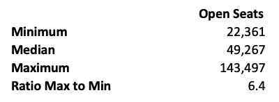
The smallest open electorate is Rabaul whilst the largest open electorate is Lagaip-Porgera. Lagaip-Porgera is more than six times larger than Rabaul. Both seats elect one member of parliament.
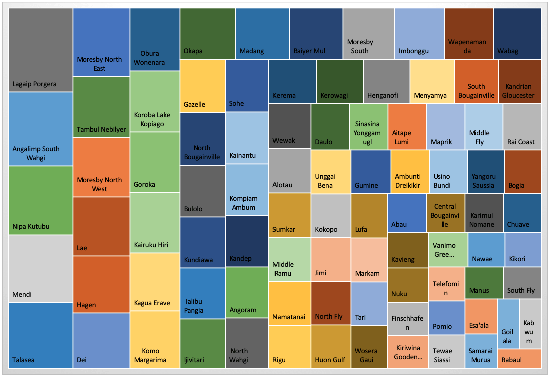
The discrepancies in size of open electorates are visualised in the chart below.
Malapportionment in open electorates (based on the roll)
Although there does not appear to be any legislation governing malapportionment in existing seats in PNG, when new electorates are created, the degree to which an electorate can deviate from population equality is 25 per cent. Currently, the median open seat has 49,267 voters – 25 per cent lower would be 36,950, 25 per cent higher would be 61,584. Obviously, the present range of open seat electoral rolls exceeds the variance allowed for new seats.
With such major malapportionment, it seems high time to tackle the issue and divide larger electorates.
The rise of malapportionment in PNG electorates appears to have been passive – a product of previous governments neglecting to periodically redraw boundaries. One solution to passive malapportionment would be to require redistricting at established intervals. For PNG, one possibility for conducting a redistricting exercise would be after each national census is conducted. This would be useful, in that (if accurate) census data could guide decisions. Conveniently, national censuses in PNG follow a ten-year cycle, while elections follow a five-year cycle.
There will be challenges with any attempts at correcting malapportionment though. The current Organic Law on Provincial Governments and LLGs only allows for two additional open seats to be created, for a total of 91 open electorates. Before any serious redistricting exercise is undertaken, an amendment to the Organic Law would need to be made.
Even setting aside changes in legislation, the fate of redistricting lies in the hands of politicians. Although Electoral Boundary Commission reviews were conducted in 1981, 1985-86, 1991, 2005 and 2011, the boundaries of open electorates haven’t changed since PNG’s independence. (The only redistricting that has occurred post-independence was the creation of two additional provinces – Hela and Jiwaka – in the wake of the 2011 Boundary Commission report.)
PNG, like other countries such as Mauritius and Malaysia, allows parliament to either accept or reject proposed redistricting plans but does not grant it the authority to modify the plan. Although parliament is not allowed to modify redistricting plans, political party representatives are part of PNG’s Electoral Boundary Commission. This increases the risk of the Boundary Commission not being politically neutral. Party representation on a Boundary Commission may lead to gerrymandering of electorates – the redrawing of electoral boundaries to favour certain politicians or parties.
Of those 27 open seats that are, on the basis of the roll, more than 25 per cent larger than the median open electorate, 63 per cent are in the Highlands. Although it is hard to track current political affiliations, 18 of the larger open seats’ MPs were affiliated with parties at the time of the election. Any redistricting of open seats would involve a large number of seats in the Highlands region, home to many of the country’s most powerful politicians. It would also involve seats held by parties with representatives on the Boundaries Commission.
There is a real need to tackle malapportionment in PNG and, if the next census is run well, shortly after it is completed, population data could be a useful guide in tackling the issue. However, any changes to malapportionment will be tough. The law will need to be changed if the issue is to be properly tackled. And then the actual process of creating new electorates will be politically fraught. PNG faces a genuine electoral dilemma with malapportionment. The issue needs addressing. However, the pathway to addressing it successfully won’t be an easy one.

Gazelle District in ENB is so large that development issues and infrastructure repairs takes long time. Can the district be split with some LLGs to be moved to Rabaul and Kokopo Open? Can the electoral boundaries be reviewed and moved?
Thank you for the information. Very insightful.
Two follow ups.
1. On Twitter, Jonathan Pryke made a point which I’d also been wondering about: redistricting would almost certainly bring significantly more seats to the Highlands. (Or it would were it to actually tackle malapportionment.) Would PNG’s political settlement cope with this? It’s very unclear that MPs from elsewhere would tolerate it.
2. In news today, PNG’s beleaguered electoral commissioner said any boundary review was unlikely prior to the next census. The reason: no funding. This is a perennial issue. https://www.thenational.com.pg/review-unlikely-says-gamato/
Problems exist with electoral boundaries, other than population distributions. Electorates are also Districts and so are administrative units.
Ambunti-Dreikikir District comprises the foothills around Drekikir and the Sepik River valley at Ambunti. To travel from Dreikikir to Ambunti, for example to obtain a trade store licence, or to carry out some other adminisrative task, one must get a PMV to Maprik, then a PMV to Pagwi on the river, then a canoe to Ambunti. As some administrative functions are located in Ambunti and others in Dreikikir, the people of Ambunti must do the opposite to get to Dreikikir. On arrival at Dreikikir or Ambunti, the likelihood is great that the required office will be closed or the needed public servant will not at work, on the day you arrive.
For the last few years, the MP for this electorate has apppointed his own District Administrator resident at Ambunti, while the government appointed administrator has been resident at Dreikikir. The outcome has been almost complete inertia in this District.
Some years ago while visiting the National Mapping Office, I was shown how the laws of PNG that define the PNG Districts (they describe in words, in latitudes and longitudes, where the boundaries are located on the ground), contain typographical errors, such that when an attempt is made to plot the boundaries on a map, using the legal definitions, some District boundaries do not form a closed polygon. One outcome is that some isolated voters have voted in the wrong electorate, if they voted at all.
Thanks Bryant,
That’s very helpful to know.
Terence
While I agree with your recommendation for the reviewing and redrawing of the district boundaries since PNG’s population is constantly growing every year, to define the size of the districts solely on population and redrawing boundaries based on that criterion could also lead to inequality as well. Since the land mass, especially in the highlands region where it is highly populated, won’t get any bigger, what are other options aside from redrawing boundaries and what options are there for the sparsely populated but geographically larger districts? Equality should be based on access to services not just on the DSIP kina per head factor.
Thank you Ellen, although DSIP per head is disparate across electorates, each province still receives an overall budget proportionate to its size, which means the largest electorates do get larger funding for specific services. Although population isn’t the only factor in determining political boundaries, from a services and management perspective, it is still be very important. Simply redrawing and/or splitting electorates reduces population per electorate, means smaller populations are easier to reach and manage, higher DSIP per head, and each voter casts an equal vote (at present a vote in Rabaul is worth 6 in Laigap-Porgera). This will occur regardless of geography.
Valid points. I totally agree with your points.
Thank you Billy
One of the issues with the current method based on population is that it doesn’t account for provinces with large land masses and scattered populations even if its less than the number required for a new district. For instance, Western Province has vast landmass, which makes service delivery challenging. The same can be said of Manus, with Islands people scattered on the many islands.
New district boundaries should also consider provinces with vast boundaries even if population is relatively small.
Thank you Michael — that’s a very interesting point.
My thinking is that — ideally — the issue of geography’s impact on service delivery should not prevent PNG from aiming for more equal district sizes.
The issue of geographical challenges is real. But (again ideally) I think geography would be best dealt with by including geography as a factor when the amount of funding to different provinces and districts is calculated.
I admit, my approach, which seems ideal to me, might not be practically possible: political settlements are always complicated. If my approach isn’t realistic, then the issue you identified stands, and needs to be included in considerations.
Thank you for a thought-provoking comment.
Terence